Click on highway icon to see live webcams!
West East North South East Denver Metro
< Denver National Parks
Loveland Pass Colorado Springs Grand Lake Boulder Berthoud Pass Pueblo Greeley Alamosa Conifer Longmont Holyoke Durango
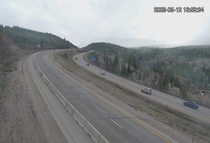
Vail Pass Berthoud Pass Loveland Pass Rabbit Ears Pass Monarch Pass Wolf Creek Pass
Red Mountain Pass
More
<
US 6 MP 272.95 EB : 0.3 miles E of 19th St in Golden
I-70 MP 259.10 WB : 0.3 miles E of US 40/CR 93 in Golden
US 40 MP 284.90 EB at T-Rex Park and Ride in Golden
I-70 MP 257.00 EB : 1.0 mile E of Lookout Mountain
I-70 MP 256.60 WB : 0.6 miles E of Lookout Mountain
I-70 MP 256.00 WB at Lookout Mountain
I-70 MP 251.65 EB : 0.3 miles E of in Evergreen Pkwy in Evergreen
I-70 MP 250.75 EB at El Rancho in Evergreen
I-70 MP 250.15 WB : 0.8 miles W of El Rancho in Evergreen
I-70 MP 249.10 WB : 1.4 miles E of CR 65
I-70 MP 247.60 EB at CR 65 E
I-70 MP 246.60 EB at Homestead Rd W
I-70 MP 245.40 WB : 1.2 miles E of US 6/US 40
I-70 MP 244.35 EB at US 6/US 40 1
I-70 MP 243.75 WB : 0.5 miles W of US 6/US 40
I-70 MP 243.25 WB : 0.3 miles E of Central City Pkwy
I-70 MP 242.85 WB : 0.2 miles W of Central City Pkwy
I-70 MP 242.45 WB at E Veterans Memorial Tunnels
I-70 MP 241.65 EB : 0.6 miles W of Veterans Memorial Tunnels
I-70 MP 239.65 EB at CO 103/13th Ave in Idaho Springs
I-70 MP 239.15 WB : 0.3 miles E of Stanley Rd/CR 312
I-70 MP 239.05 EB : 0.2 miles E of Stanley Rd/CR 312
I-70 MP 238.90 EB at Stanley Rd/CR 312 in Idaho Springs
I-70 MP 238.50 WB : 0.5 miles W of Stanley Rd/CR 312
I-70 MP 238.05 EB : 0.3 miles E of Fall River Rd
I-70 MP 237.65 EB at Fall River Rd
I-70 MP 236.55 EB : 1.1 miles W of Fall River Rd
I-70 MP 235.85 WB : 0.8 miles E of Stanley Rd in Dumont
I-70 MP 231.75 EB : 0.1 miles W of US 40
I-70 MP 235.00 WB at Stanley Rd in Dumont
I-70 MP 234.20 EB at Mountain St in Dumont
I-70 MP 233.65 WB : 0.7 miles W of Mountain St in Dumont
I-70 MP 233.30 WB : 0.9 miles W of Mountain St in Dumont
I-70 MP 232.60 WB : 0.7 miles E of US 40
I-70 MP 231.90 EB at US 40
I-70 MP 235.50 EB : 0.6 miles E of Stanley Rd in Dumont
I-70 MP 230.45 EB : 1.4 miles W of US 40
I-70 MP 228.50 WB at Georgetown Truck Parking W
I-70 MP 228.00 WB : 0.1 miles E of 15th St in Georgetown
I-70 MP 226.50 EB : 0.9 miles E of Woodward St in Silver Plume
I-70 MP 225.80 WB : 0.1 miles E of Woodward St in Silver Plume
I-70 MP 225.50 WB : 0.2 miles W of Woodward St in Silver Plume
I-70 MP 224.05 WB : 2.0 miles W of Woodward St in Silver Plume
I-70 MP 223.35 WB : 2.1 miles E of Stevens Gulch Rd in Bakerville
I-70 MP 223.20 WB : 1.9 miles E of Stevens Gulch Rd in Bakerville
I-70 MP 222.25 WB : 1.1 miles E of Stevens Gulch Rd in Bakerville
I-70 MP 221.30 EB at Stevens Gulch Rd in Bakerville
I-70 MP 220.45 WB : 0.9 miles W of Stevens Gulch Rd in Bakerville
I-70 MP 218.60 WB : 0.2 miles E of Herman Gulch Rd
I-70 MP 217.40 WB : 1.0 mile W of Herman Gulch Rd
I-70 MP 215.90 WB : 0.7 miles E of Eisenhower Tunnel
I-70 MP 215.60 EB : 0.3 miles E of Eisenhower Tunnel
I-70 MP 213.45 EB : 0.1 miles W of Eisenhower Tunnel
I-70 MP 211.80 WB : 1.7 miles W of Eisenhower Tunnel
I-70 MP 210.65 EB : 2.9 miles W of Eisenhower Tunnel
I-70 MP 209.85 WB : 3.8 miles W of Eisenhower Tunnel
I-70 MP 208.90 WB : 3.3 miles E of US 6/CO 9 2 in Silverthorne
I-70 MP 208.00 WB : 2.4 miles E of US 6/CO 9 in Silverthorne
I-70 MP 207.05 WB : 1.6 miles E of US 6/CO 9 in Silverthorne
I-70 MP 206.85 EB : 1.4 miles E of US 6/CO 9 in Silverthorne
US 6 MP 208.70 WB at I-70 in Silverthorne
I-70 MP 204.95 EB : 0.4 miles W of US 6/CO 9 in Silverthorne
I-70 MP 204.65 EB : 0.7 miles W of US 6/CO 9 in Silverthorne
I-70 MP 204.25 EB : 1.9 miles E of CO 9 in Frisco LiveView: Looking East
I-70 MP 204.25 EB : 1.9 miles E of CO 9 in Frisco LiveView: Looking West
I-70 MP 204.25 EB : 1.9 miles E of CO 9 in Frisco LiveView: Looking at Road Surface
I-70 MP 203.80 EB : 1.5 miles E of CO 9 in Frisco LiveView: Looking East
I-70 MP 203.80 EB : 1.5 miles E of CO 9 in Frisco LiveView: Looking West
I-70 MP 203.80 EB : 1.5 miles E of CO 9 in Frisco LiveView: Looking at Road Surface
I-70 MP 203.20 EB : 0.9 miles E of CO 9 in Frisco
I-70 MP 202.35 EB at CO 9 in Frisco
I-70 MP 201.45 EB : 0.6 miles E of Main St in Frisco
I-70 MP 200.75 EB : 0.2 miles W of Main St in Frisco
I-70 MP 199.60 WB : 1.3 miles W of Main St in Frisco
I-70 MP 199.20 EB : 1.5 miles E of Officers Gulch LiveView: Looking East
I-70 MP 198.40 EB : 0.5 miles E of Officers Gulch
I-70 MP 197.80 WB at Officers Gulch
I-70 MP 196.85 EB : 1.6 miles E of CO 91 LiveView: Looking East
I-70 MP 196.85 EB : 1.6 miles E of CO 91 LiveView: Looking West
I-70 MP 196.85 EB : 1.6 miles E of CO 91 LiveView: Looking at Road Surface
I-70 MP 195.85 WB : 0.7 miles E of CO 91
I-70 MP 195.25 EB at CO 91 in Copper Mountain 1
I-70 MP 194.60 EB : 0.8 miles W of CO 91 LiveView: Looking East
I-70 MP 194.60 EB : 0.8 miles W of CO 91 LiveView: Looking West
I-70 MP 194.60 EB : 0.8 miles W of CO 91 LiveView: Looking at Road Surface
I-70 MP 194.05 EB : 1.4 miles W of CO 91 LiveView: Looking East
I-70 MP 194.05 EB : 1.4 miles W of CO 91 LiveView: Looking West
I-70 MP 194.05 EB : 1.4 miles W of CO 91 LiveView: Looking at Road Surface
I-70 MP 193.70 WB : 1.8 miles W of CO 91 LiveView: Looking East
I-70 MP 193.70 WB : 1.8 miles W of CO 91 LiveView: Looking West
I-70 MP 193.70 WB : 1.8 miles W of CO 91 LiveView: Looking at Road Surface
I-70 MP 193.10 WB : 2.6 miles W of CO 91
I-70 MP 192.10 WB : 1.8 miles E Vail Pass Summit
I-70 MP 191.75 WB : 1.6 miles E Vail Pass Summit
I-70 MP 191.35 WB : 1.5 miles E of Vail Pass Summit LiveView: Looking East
I-70 MP 191.35 WB : 1.5 miles E of Vail Pass Summit LiveView: Looking West
I-70 MP 191.35 WB : 1.5 miles E of Vail Pass Summit LiveView: Looking at Road Surface
I-70 MP 189.45 WB : 0.7 miles W of Vail Pass Summit
I-70 MP 189.45 EB : 0.7 miles W of Vail Pass Summit LiveView: Looking East
I-70 MP 189.45 EB : 0.7 miles W of Vail Pass Summit LiveView: Looking West
I-70 MP 189.45 EB : 0.7 miles W of Vail Pass Summit LiveView: Looking at Road Surface
I-70 MP 189.15 WB : 1.0 mile W of Vail Pass Summit
I-70 MP 187.25 WB : 2.6 miles W of Vail Pass Summit
I-70 MP 186.35 EB : 3.3 miles W of Vail Pass Summit
I-70 MP 186.10 EB : 3.5 miles W of Vail Pass Summit
I-70 MP 185.60 WB : 4.2 miles W of Vail Pass Summit LiveView: Looking East
I-70 MP 185.60 WB : 4.2 miles W of Vail Pass Summit LiveView: Looking West
I-70 MP 185.60 WB : 4.2 miles W of Vail Pass Summit LiveView: Looking at Road Surface
I-70 MP 185.00 WB : 4.8 miles W of Vail Pass Summit LiveView: Looking East
I-70 MP 185.00 WB : 4.8 miles W of Vail Pass Summit LiveView: Looking West
I-70 MP 185.00 WB : 4.8 miles W of Vail Pass Summit LiveView: Looking at Road Surface
I-70 MP 183.65 EB : 4.5 miles E of Big Horn Rd in Vail
I-70 MP 182.80 EB : 2.6 miles E of Big Horn Rd in Vail
I-70 MP 182.15 WB : 2.2 miles E of Big Horn Rd in Vail
I-70 MP 181.65 WB : 1.8 miles E of Big Horn Rd in Vail LiveView: Looking East
I-70 MP 181.65 WB : 1.8 miles E of Big Horn Rd in Vail LiveView: Looking West
I-70 MP 181.65 WB : 1.8 miles E of Big Horn Rd in Vail LiveView: Looking at Road Surface
I-70 MP 181.10 EB : 1.2 miles E of Big Horn Rd in Vail LiveView: Looking East
I-70 MP 181.10 EB : 1.2 miles E of Big Horn Rd in Vail LiveView: Looking West
I-70 MP 181.10 EB : 1.2 miles E of Big Horn Rd in Vail LiveView: Looking at Road Surface
I-70 MP 180.45 WB : 0.6 miles E of Big Horn Rd in Vail LiveView: Looking East
I-70 MP 180.45 WB : 0.6 miles E of Big Horn Rd in Vail LiveView: Looking West
I-70 MP 180.45 WB : 0.6 miles E of Big Horn Rd in Vail LiveView: Looking at Road Surface
I-70 MP 178.65 EB at East Vail Chain Station
I-70 MP 178.45 EB at East Central Vail Chain Station
I-70 MP 178.20 EB at West Central Vail Chain Station
I-70 MP 177.90 EB at West Vail Chain Station
I-70 MP 175.85 WB : 0.3 miles W of Vail Rd
I-70 MP 175.30 EB : 1.0 mile W of Vail Rd
I-70 MP 173.65 WB : 0.4 miles E of Charmonix Rd in Vail
I-70 MP 172.85 WB : 0.6 miles W of Charmonix Rd in Vail
I-70 MP 172.10 WB : 1.0 mile E of Dowd Junction
I-70 MP 171.75 WB : 0.7 miles E of Dowd Junction
I-70 MP 171.10 EB at Dowd Junction
I-70 MP 169.55 EB : 0.9 miles E of US 6 in Eagle
I-70 MP 168.95 WB at US 6 in Eagle
I-70 MP 166.65 WB at Avon Rd
I-70 MP 165.95 WB : 0.9 miles W of Avon Rd
I-70 MP 162.85 WB at Beard Creek Rd in Edwards
I-70 MP 160.15 WB at Wilmore Lake
I-70 MP 158.10 WB : 1.8 miles E of CO 131
I-70 MP 157.10 WB : 0.7 miles E of CO 131
I-70 MP 156.60 WB at CO 131
I-70 MP 155.80 WB : 0.9 miles W of CO 131
I-70 MP 154.20 EB : 2.8 miles W of CO 131
I-70 MP 145.80 EB : 1.0 mile W of Eby Creek Rd
I-70 MP 137.05 EB : 3.0 miles W of Trail Gulch Rd in Gypsum
I-70 MP 134.05 WB at US 6 in Dotsero
I-70 MP 133.35 WB at Colorado River Rd
I-70 MP 133.25 WB at Dotsero Truck Parking: Looking West
I-70 MP 132.30 EB : 1.3 miles W of Colorado River Rd in Dotsero
I-70 MP 130.95 WB : 3.0 miles W of Colorado River Rd in Dotsero
I-70 MP 128.80 EB : 0.2 miles E of Bair Ranch Rest Area
I-70 MP 128.10 WB : 0.5 miles W of Bair Ranch Rest Area
I-70 MP 123.15 EB : 2.2 miles E of Grizzly Creek
I-70 MP 122.50 WB : 1.5 miles E of Grizzly Creek
I-70 MP 120.85 WB : 0.2 miles W of Grizzly Creek Rest Area
I-70 MP 118.70 EB at No Name Lane
I-70 MP 118.00 EB at E No Name Tunnel
I-70 MP 118.25 EB : 0.3 miles E of No Name Tunnel
I-70 MP 117.65 WB at W No Name Tunnel
I-70 MP 116.85 EB : 0.4 miles E of Grand Ave in Glenwood Springs
I-70 MP 116.60 EB at Grand Ave in Glenwood Springs
I-70 MP 116.20 EB : 0.4 miles W of CO 82 in Glenwood Springs
I-70 MP 115.95 EB : 0.8 miles W of CO 82 in Glenwood Springs
I-70 MP 108.95 WB at Canyon Creek Rd: Looking East
I-70 MP 108.95 WB at Canyon Creek Rd: Looking West
I-70 MP 096.40 EB : 1.2 miles W of 9th St: Looking East
I-70 MP 096.40 EB : 1.2 miles W of 9th St: Looking West
I-70 MP 096.40 EB : 1.2 miles W of 9th St: Looking at Road Surface
I-70 MP 086.10 EB : 0.8 miles W of Rifle: Looking East
I-70 MP 086.10 EB : 0.8 miles W of Rifle: Looking West
I-70 MP 086.10 EB : 0.8 miles W of Rifle: Looking at Road Surface
I-70 MP 074.65 EB at CO 215 in Parachute: Looking East
I-70 MP 074.65 EB at CO 215 in Parachute: Looking West
I-70 MP 062.80 WB : 1.5 miles E of Roan Creek Rd in De Beque: Looking East
I-70 MP 062.80 WB : 1.5 miles E of Roan Creek Rd in De Beque: Looking West
I-70 MP 054.40 WB : 3.8 miles E of Beavertail Tunnel: Looking East
I-70 MP 054.40 WB : 3.8 miles E of Beavertail Tunnel: Looking West
I-70 MP 050.35 EB at Beavertail Tunnel: Looking East
I-70 MP 050.35 EB at Beavertail Tunnel: Looking West
I-70 MP 043.75 EB at US 6 in Palisade: Looking East
I-70 MP 043.75 EB at US 6 in Palisade: Looking West
I-70 MP 043.75 EB at US 6 in Palisade: Looking at Road Surface
I-70 MP 032.35 EB : 1.1 miles E of Horizon Dr in Grand Junction: Looking East
I-70 MP 032.35 EB : 1.1 miles E of Horizon Dr in Grand Junction: Looking West
I-70 MP 023.10 EB : 2.7 miles W of River Rd in Grand Junction: Looking East
I-70 MP 023.10 EB : 2.7 miles W of River Rd in Grand Junction: Looking West
I-70 MP 015.00 WB at CO 139 in Loma: Looking North
I-70 MP 015.00 WB at CO 139 in Loma: Looking East
I-70 MP 015.00 WB at CO 139 in Loma: Looking West
I-70 MP 014.70 EB at Loma Port of Entry: Looking East
I-70 MP 000.65 EB : 0.9 miles E of Utah Border: Looking West
I-70 MP 000.65 EB : 0.9 miles E of Utah Border: Looking East
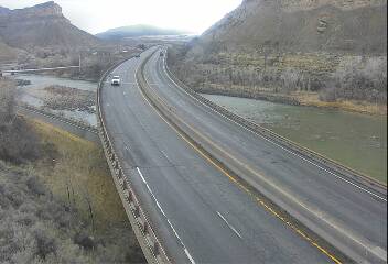
I-70 at Utah Border (I70 Liveview WB @ Milepost 226.4 GR)
<
<
Find cams in your favorite town, listed A-Z!
A-Z Abbey, Colorado Weather Cams Alamosa, Colorado Weather Cams Allenspark, Colorado Weather Cams Arapahoe Basin, Colorado Weather Cams Archived Footage Arvada, Colorado Weather Cams Aspen, Colorado Weather Cams Ault, Colorado Weather Cams Aurora, Colorado Weather Cams Badger Mountain, Colorado Weather Cams Beaver Creek, Colorado Weather Cams Berthoud Pass Road Conditions Berthoud Pass, Colorado Weather Cams Black Canyon NP, Colorado Weather Cams Black Hawk, Colorado Weather Cams Boulder, Colorado Weather Cams Breckenridge, Colorado Weather Cams Broomfield, Colorado Weather Cams Buena Vista, Colorado Weather Cams Burlington, Colorado Weather Cams Buttermilk, Colorado Weather Cams Byers, Colorado Weather Cams Cañon City, Colorado Weather Cams Carbondale, Colorado Weather Cams Castle Rock Weather Cams Centennial, Colorado Weather Cams Central City, Colorado Weather Cams Coal Creek Canyon, Colorado Weather Cams Colorado Air and Space Port, Colorado Weather Cams Colorado National Monument, Colorado Weather Cams Colorado Pass Road Conditions Colorado Springs, Colorado Weather Cams Conifer, Colorado Weather Cams Contact us Continental Divide, Colorado Weather Cams Copper Mountain, Colorado Weather Cams Cortez, Colorado Weather Cams Crested Butte, Colorado Weather Cams Crestone/Sangre de Cristo Mountains, Colorado Weather Cams Cripple Creek, Colorado Weather Cams Cuchara Valley, Colorado Weather Cams Curecanti National Recreation Area, Colorado Weather Cams Dakota Hill, Colorado Weather Cams Denver Road Conditions Denver, Colorado Weather Cams Durango, Colorado Weather Cams Eagle County Airport, Colorado Weather Cams Eisenhower Tunnel (I-70) Traffic Cams Eldora Mountain Resort, Colorado Weather Cams Estes Park, Colorado Weather Cams Evergreen, Colorado Weather Cams Fairplay, Colorado Weather Cams Fort Collins, Colorado Weather Cams Fort Morgan, Colorado Weather Cams Fountain, Colorado Weather Cams Fraser, Colorado Weather Cams Frisco, Colorado Weather Cams Georgetown, Colorado Weather Cams Glenwood Springs, Colorado Weather Cams Golden, Colorado Weather Cams Gothic, Colorado Weather Cams Granby Ranch Ski Resort, Colorado Weather Cams Granby, Colorado Weather Cams Grand Junction, Colorado Weather Cams Grand Lake, Colorado Weather Cams Greeley, Colorado Weather Cams Gunbarrel, Colorado Weather Cams Gunnison, Colorado Weather Cams Hayden, Colorado Weather Cams Highway 93 (Boulder to Golden) Colorado Weather Cams Holyoke, Colorado Weather Cams Hotchkiss, Colorado Weather Cams Hygiene, Colorado Weather Cams I-225 Road Conditions I-25 I-25 North Road Conditions Colorado I-25 South Road Conditions I-270 Road Conditions I-70 East Road Conditions I-70 WEST Road Conditions I-76 Road Conditions Idaho Springs, Colorado Weather Cams Keystone, Colorado Weather Cams Kremmling, Colorado Weather Cams La Veta Pass, Colorado Weather Cams Lake Granby, Colorado Weather Cams Lamar, Colorado Weather Cams Leadville, Colorado Weather Cams Limon, Colorado Weather Cams Littleton, Colorado Weather Cams Live Colorado Webcams Live Map Colorado Traffic Cams Longmont, Colorado Weather Cams Loveland Pass Road Conditions Loveland Ski Area, Colorado Weather Cams Loveland, Colorado Weather Cams Lyons, Colorado Weather Cams Manitou Springs, Colorado Weather Cams Meeker, Colorado Weather Cams Mesa Verde National Park, Colorado Weather Cams Monarch Mountain Ski Area, Colorado Weather Cams Monarch Pass Road Conditions Monarch Pass, Colorado Traffic Cams Montrose, Colorado Weather Cams Monument Hill, Colorado Traffic Cams Morrison, Colorado Weather Cams Mount Princeton, Colorado Weather Cams National Parks, Colorado Weather Cams Nederland, Colorado Weather Cams Ouray, Colorado Weather Cams Pagosa Springs, Colorado Weather Cams Pikes Peak, Colorado Weather Cams Pine, Colorado Weather Cams Poncha Springs, Colorado Weather Cams Powderhorn Mountain Resort, Colorado Weather Cams Pueblo, Colorado Weather Cams Purgatory Resort, Colorado Weather Cams Rabbit Ears Pass, Colorado Road Conditions Rangely, Colorado Weather Cams Red Feather Lakes, Colorado Weather Cams Red Mountain Pass, Colorado Road Conditions Red Rocks Park Weather Cams Redstone, Colorado Weather Cams Ridgway, Colorado Weather Cams Rifle, Colorado Weather Cams Rocky Mountain National Park, Colorado Weather Cams Saguache County, Colorado Weather Cams Salida, Colorado Weather Cams San Juan Mountains, Colorado Weather Cams Silverthorne, Colorado Weather Cams Ski Cooper, Colorado Weather Cams Ski resorts! Snow Stakes! Snowmass, Colorado Weather Cams Steamboat Springs, Colorado Weather Cams Sterling, Colorado Weather Cams Sunlight Mountain, Colorado Weather Cams Superior, Colorado Weather Cams Telluride, Colorado Weather Cams Thornton, Colorado Weather Cams Trinidad, Colorado Weather Cams US 160 Colorado Road Conditions US 24 Colorado Road Conditions US 285 Colorado Road Conditions US 287 Colorado Road Conditions US 34 Colorado Road Conditions US 36 Colorado Road Conditions US 385 Colorado Road Conditions US 40 Colorado Road Conditions US 50 Colorado Road Conditions US 550 Colorado Road Conditions US 6 Colorado Road Conditions US 85 Colorado Road Conditions US-36 Vail Pass Road Conditions Vail, Colorado Weather Cams Walden, Colorado Weather Cams Westcliffe, Colorado Weather Cams Westminster, Colorado Weather Cams Wilkerson Pass, Colorado Web Cams Windsor Weather Cams Winter Park Weather Cams Wolf Creek Pass Road Conditions Wolf Creek Pass Traffic Cams Wolf Creek Ski Weather Cams Woodland Park Weather Cams Wray, Colorado Weather Cams Wyoming/Colorado border (I-25) Yuma, CO Weather Cams
To provide the best experiences, we use technologies like cookies to store and/or access device information. Consenting to these technologies will allow us to process data such as browsing behavior or unique IDs on this site. Not consenting or withdrawing consent, may adversely affect certain features and functions.
The technical storage or access is strictly necessary for the legitimate purpose of enabling the use of a specific service explicitly requested by the subscriber or user, or for the sole purpose of carrying out the transmission of a communication over an electronic communications network.
The technical storage or access is necessary for the legitimate purpose of storing preferences that are not requested by the subscriber or user.
The technical storage or access that is used exclusively for statistical purposes.
The technical storage or access that is used exclusively for anonymous statistical purposes. Without a subpoena, voluntary compliance on the part of your Internet Service Provider, or additional records from a third party, information stored or retrieved for this purpose alone cannot usually be used to identify you.
The technical storage or access is required to create user profiles to send advertising, or to track the user on a website or across several websites for similar marketing purposes.
Manage consent


 See I-70 Cameras in Utah!